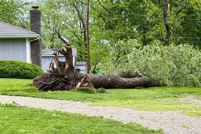
Southern Johnson County saw more downed trees and power outages following storms that started Sunday evening and lasted off and on through early Monday morning.
Overall, rain totals from the storm topped 2 1/2 inches in some parts of Johnson County.
City crews with Spring Hill were still working on clearing the trees as of Monday afternoon.
About 100 households in the southern Johnson County town were affected by power outages that Evergy worked to restore, including areas south of West Hale Street along South Madison Street, just northwest of Spring Hill City Park and where South Ridgeview Road and 207th Street meet.
As of Monday afternoon, Evergy’s online outage map was reporting more than 140 active outages in the Kansas City region, impacting more than 3,600 customers.
Spring Hill was encouraging people to avoid the area between South and North streets, as it had a higher concentration of debris.
“Whew — another doozy!” the city said on its Facebook post Monday morning. “We will have another tree debris pickup. Stay tuned on our social media platforms and Notify Me [app] for more information about when this will happen.”
Where did it rain the most?
Here are the top rainfall totals as reported by Johnson County Stormwatch, which monitors real-time data collected from more than 100 measuring sites across the county. (Data has not been independently verified.)
- De Soto @ 95th and Kill Creek: 2.83 in.
- Shawnee @ Woodland and Clear Creek: 2.76 in
- De Soto @ 102nd and Lexington: 2.72 in.
- Shawnee @ 75th and K-7: 2.52 in.
- Overland Park @ 199th and Newton: 2.52 in.
- Lenexa @ Woodland and Coon Creek: 2.36 in.
- Shawnee @ Tomahawk Hills Golf Course: 2.36 in.
- Shawnee @ SM Parkway and Mill Creek: 2.36 in.
- De Soto @ De Soto Streamway Park: 2.24 in.
- Shawnee @ 67th and Caenen St.: 2.24 in.
- Mission Hills @ Mission Road and Rock Creek: 2.23 in.
- Fairway @ Mission Road and Rock Creek: 2.23 in.
Tornado warning issued just after 5:30 a.m. Monday
The storms came in multiple rounds overnight and into the hours around dawn on Monday.
Beginning late Sunday afternoon, storms swept across the Kansas City metro, resulting in downed trees, scattered debris and flooding.
Several communities were placed under a severe thunderstorm watch and later a flood warning.
At 5:37 a.m. Monday, the National Weather Service issued a tornado warning covering Spring Hill and other parts of southern Johnson County, which was in effect until 6 a.m.
Tornado Warning including Grandview MO, Belton MO and Spring Hill KS until 6:00 AM CDT pic.twitter.com/vkdjQw9GXB
— NWS Kansas City (@NWSKansasCity) April 27, 2026
The move prompted tornado sirens to go off further north in Johnson County, too, including in Overland Park.
Around 6 a.m., winds were reported to reach up to 46 miles per hour as observed at the Johnson County Executive Airport in Olathe, according to the National Weather Service. That met the threshold for a gale wind, which breaks twigs and small branches and can impede walking.
Other JoCo cities impacted
The city of Edgerton also reported power outages, though power was restored around 8:20 a.m.
The city of Gardner also saw some damage, with city crews removing a tree limb from 199th Street and reports of a downed tree near 167th and Poplar streets.
However, Gardner Communications Manager Daneeka Marshall-Oquendo said the city hadn’t received any reports of significant storm damage or power outages.
April 13 storm still having impacts in Spring Hill
Since the start of the rainy season this year, Johnson County has seen quite a bit of storm damage, including damage from the March 7 EF-0 tornado that touched down in Shawnee and Merriam and several storms since.
For Spring Hill, a storm on April 13 was particularly bad. Residents reported uprooted trees, scattered debris and even flooding.
It was part of a cluster of three confirmed tornadoes in the region that also did heavy damage in parts of Franklin and Miaimi counties, including in Ottawa and Hillsdale, Kansas.
Spring Hill’s initial response to that storm was that no city resources would be provided for cleanup because the damage wasn’t widespread enough. That caused an outcry from the community, prompting the city to change course.
“We didn’t necessarily have a plan for anything under the threshold of, I would say, natural disaster for the whole city,” said Mayor Chad Young during Thursday’s city council meeting, where the city council talked about storm policies moving forward.
The city does set aside funds for emergencies and circumstances like this, however, Young said he wants to formalize the process for future storms that fall under the threshold of natural disaster.
“The [April 13] storm was a little bit of an anomaly,” Young said. “We had quite a bit of damage in the area where the damage was, but it wasn’t necessarily the entire city and it was on the Miami County side. Therefore, we had a very, very small portion of Johnson County that was affected and that affects what happens as far as resources we get from all over.”
Spring Hill is divided between Johnson and Miami counties, with most of the town on the Johnson County side.
While the city council took no formal action on Thursday, city staff have been asked to put together a proposal outlining options for non-widespread storm damage, including funding and potential contractors for tree removal.
“Hopefully in the future, all our communication will be, ‘This day is when pickup will start,’ and we don’t have to go through the rigamarole,” Young said.