By the Johnson County Museum
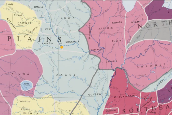
For generations, Indigenous peoples lived on, traveled through, hunted and fished in, and maintained connections to the area that would later become Johnson County in 1855.
For hundreds of years, it was part of the ancestral homelands of the Osage and Kaw (Kanza). During the 1800s, federal removal policies reshaped the region, and much of this area became part of the Shawnee Reservation. Potawatomi people also passed through during their forced removal from Indiana to present-day Miami County.
The histories of these tribal nations are distinct, but each helps us understand the land before the county boundaries we know today existed.
Read on to learn more about the Indigenous homelands, removals, and reservations that preceded the creation of Johnson County.
Setting the stage
As the United States spread westward in the early 1800s, the federal government pursued policies that removed Indigenous populations from lands sought by Euro-Americans. Native nations east of the Mississippi River – and later in Missouri and other areas farther west – were forced or pressured to cede their homelands and relocate.
This process reshaped the land that would later become Johnson County. Indigenous nations with longstanding ties to the region were displaced, while other Native peoples who had been removed from their own homelands were relocated here.
By the mid-1820s, much of what is now Kansas had become part of a large Indian Territory that also included present-day Oklahoma, Nebraska, and lands farther north. For roughly three decades, the region became home to numerous tribal nations living on reservations established by the federal government.
The Kaw and the Osage
In 1776, when the U.S. was founded on the East Coast, the land that would become Johnson County, Kansas, was not part of the new nation.
It was part of the homelands of the Osage and Kanza (Kaw) — Indigenous nations with long histories, complex societies, and growing territories.
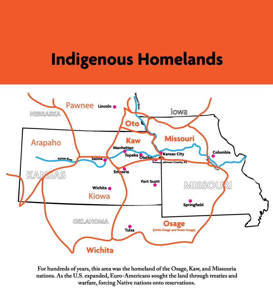
During the late 1700s, the Osage territory and influence expanded across parts of what are now Missouri, Kansas, Oklahoma, and Arkansas. In fact, the Osage Empire grew by more than 100,000 square miles during that time, a growth rate faster than the U.S.
By 1825, Missouri had become a state, and pressure was growing to make more land available for Euro-American settlement.
That June, William Clark — of Lewis and Clark fame and then Superintendent of Indian Affairs — met with leaders of the Shawnee, Osage, Kaw, and other tribes in St. Louis. The federal government sought land in Missouri for settlement and wanted Native nations relocated west of the state.
Through treaties shaped by pressure, unequal power, and strategic compromise, tribal leaders ceded ancestral territories in exchange for reservation lands west of Missouri’s border. The federal government’s treaties with the Osage and Kaw tribes forced their removal to reservations in present-day Kansas.
Their removal also made it possible for the government to relocate other Native peoples — including the Shawnee — to reservation lands farther west.
The Shawnee reservation
During the 1820s, the federal government removed the Shawnee Tribe from its ancestral territory in the Ohio River Valley and scattered lands in Missouri, to the emerging Indian Territory in Kansas. The Shawnee people were directed to a rectangular piece of land that would become their reservation from the late 1820s through the early 1850s.
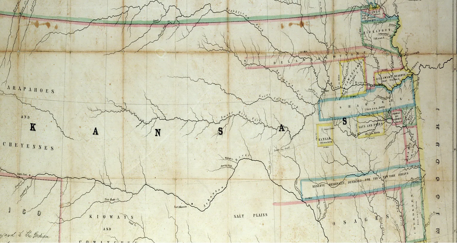
The Shawnee reservation spanned the area that later became Johnson County, extended into present-day Miami County, and stretched west to Topeka.
Many Shawnee tribal members chose land in the northern and central portions of what is now Johnson County. A central gathering place developed near present-day Shawnee, Kan., while Methodist, Baptist, and Quaker missions operated near the Missouri border.
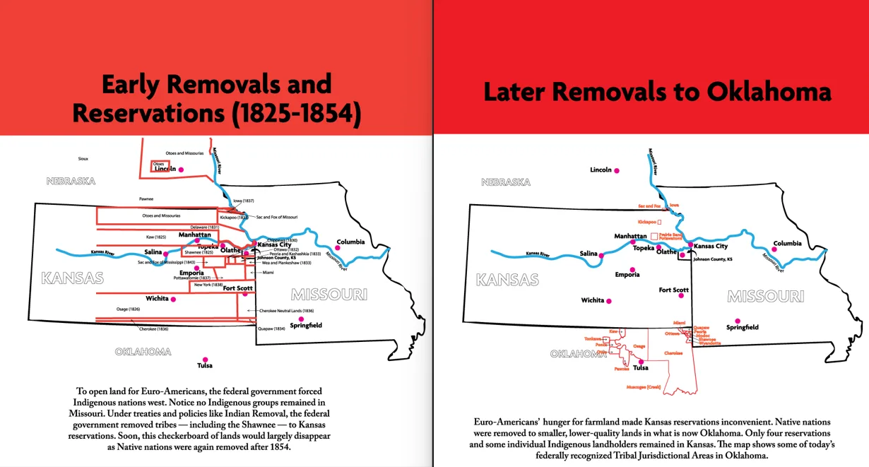
Although the Santa Fe Trail and later, the Oregon and California trails, crossed the reservation, Euro-American settlers were not permitted to purchase lands on the Shawnee reservation or the others that lined the Missouri border by the late 1830s (see image 3).
The Potawatomi Trail
Like the Shawnee, the Potawatomi were removed from their ancestral Great Lakes territories in Wisconsin, Illinois, Indiana, and Michigan to reservations west of the Mississippi River. Following an 1833 treaty signed in Chicago, Potawatomi people were relocated west of the Mississippi River. Some were moved first to the Platte region of Missouri and later to reservation lands farther west.
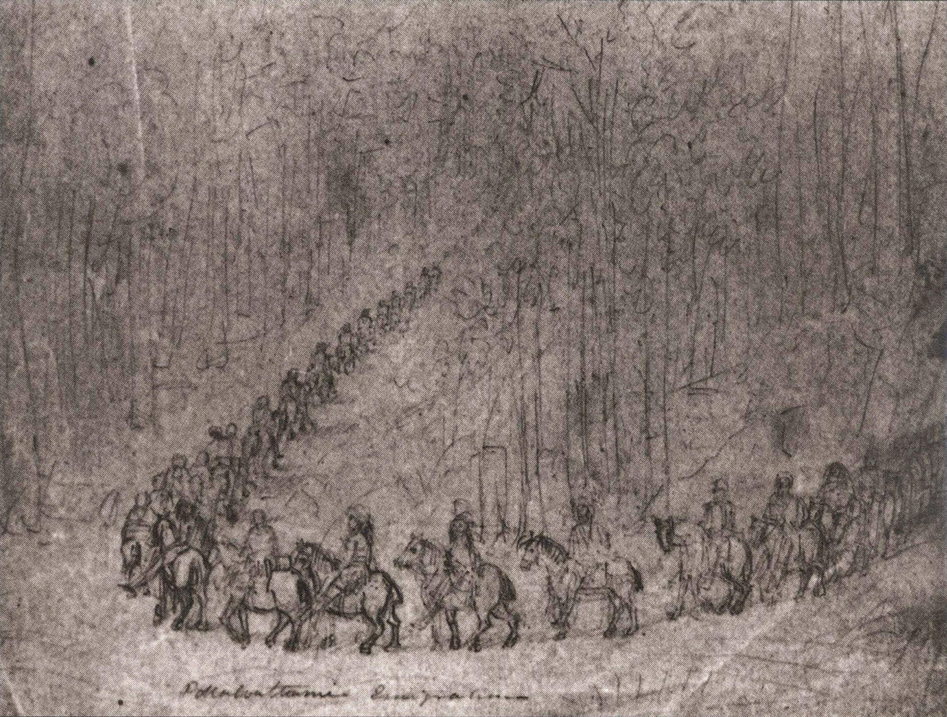
A second Potawatomi reservation was established in present-day Miami County, Kansas. The Potawatomi sent there were forcibly removed from their homelands in northern Indiana and southern Michigan. This removal was so horrific, it became known as the “Trail of Death.”
On Sept. 4, 1838, 859 Potawatomi were rounded up, detained, and marched at gunpoint 660 miles from Twin Lakes, Ind. to Osawatomie, Kan. On the 60th day of the removal, the party crossed over the Missouri River and soon entered into Johnson County. The group traveled south, camping in the vicinity of the Blue River and Bull Creek, before moving on toward their destination.
The end of the Shawnee Reservation
In 1854, Congress created the Kansas and Nebraska Territories and opened the land for Euro-American purchases. This change meant that Kansas reservations were disbanded and their tribal members removed to new reservations. Today, only four small reservations remain in Kansas.
For Shawnee tribal members, federal policy presented another difficult choice: move again to a smaller Indian Territory — present-day Oklahoma — in order to maintain traditional communal land practices, or remain in Kansas as individual landowners under a system modeled on Euro-American property ownership.
Each Shawnee man, woman, and child who stayed in Kansas received 200 acres of land from the government. The Shawnee Tribe split over the decision, but many members chose to live in this well-watered and forested area. Their land parcels were mapped in the late 1850s.
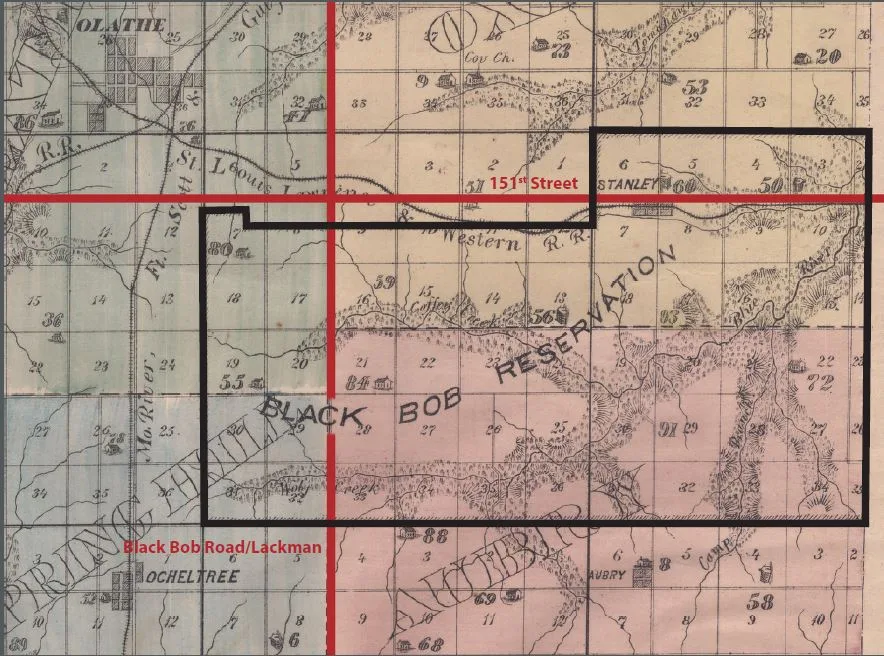
Within 20 years, however, hardly any of these Shawnee landholders retained their land — many eventually removed to the reservation in Indian Territory in Oklahoma.
Refusing removal
One group of Shawnee resisted both another removal and the system of individual allotments.
The Black Bob Band of the Shawnee, located in the southeastern portion of the county, claimed their allotments as a single, 33,000-acre tract known as the Black Bob Reservation.
The violence and upheaval of the Border War, combined with incursions by Euro-American squatters, undermined the Black Bob Band’s efforts to retain their land. Ultimately, band members lost their land claims and removed to Oklahoma. (Read more about the Black Bob Band in this JoCoHistory Blog post).
What remains today
Much of this history can be difficult to see on the modern landscape, but traces remain.
Some of the homes and structures built by Shawnee tribal members who stayed in Kansas Territory still stand. A Shawnee cemetery and the Methodist mission site remain.
Schools, streets, parks, and other features throughout Johnson County bear the names of Shawnee tribal members. Far fewer visible reminders recognize the Osage and Kaw peoples whose connections to this land extend much farther back.
The Potawatomi Trail of Death is also remembered. Every few years, the Potawatomi Trail of Death Association organizes a commemorative caravan following the removal route from Indiana, through Johnson County, and to the former reservation site in Kansas. [images 6 and 7]
Museums, historic sites, tribal histories, written records, and interpretive panels also help preserve and share this history. Throughout JCPRD parks, “History in the Park” panels connect visitors with stories tied to the places where they are standing.
This history took place before Johnson County existed.
Understanding it helps us better understand the land, communities, and circumstances from which Johnson County would later emerge in 1855.
Learn more!
There are many ways to learn more about the Indigenous history of this area and the surrounding region.
Visit museums and historic sites, including the Haskell Indian Nations University Cultural Center and Museum. Search JoCoHistory.org for photographs, maps, documents, and local history resources. And the next time you visit a JCPRD park, look for a “History in the Park” interpretive panel to learn more about the history connected to that place.
You can also explore this history in the Johnson County Museum’s signature exhibit, “Becoming Johnson County.” The exhibit is included with regular museum admission and is open Monday through Saturday, 9 a.m.–4:30 p.m.
Plan your visit at JCPRD.com/Museum.
A Note about representation and collecting
The earliest materials in the Johnson County Museum’s collections date to the 1820s. Few records or images in our collections document this area before frequent Euro-American contact during the 1820s and 1830s.
Our collections currently contain no known depictions of Kaw or Osage people on their ancestral lands here and relatively few materials representing Shawnee tribal members.
There are gaps in the more recent record, too. Native people continue to live and work in Johnson County, making up about 0.6% of the county’s population in the 2020 Census. Yet the museum’s collections include relatively little that documents their lives, work, families, communities, and contributions to the Johnson County of today.
Those absences matter. They shape what the museum can interpret through objects, photographs, and personal stories, and they remind us that a museum collection is never a complete record of the past — or the present.
The museum continues to seek materials that can help us better represent these histories and experiences. If you have objects, photographs, documents, or stories that may help, or would like to contact the curator of collections, please email [email protected].